
- The Challenge and the Objective
Target Area: A 32 km² area
Objective: To identify undiscovered gas pockets within an existing gas condensate field.
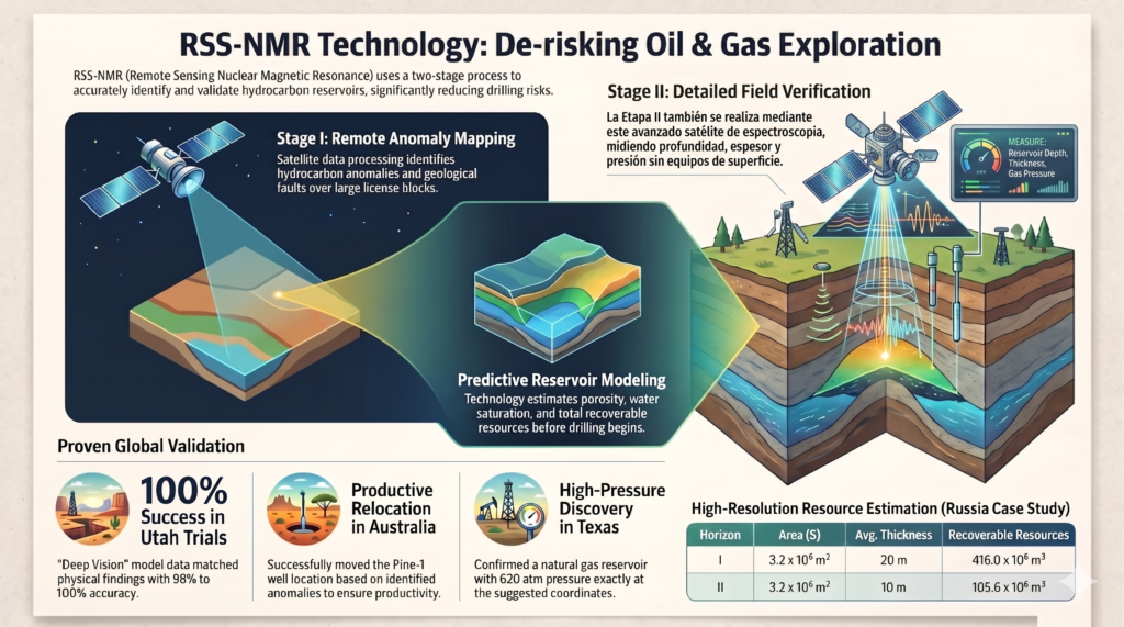
- The Two-Phase Process (RS-NMR Technology)
Remote Sensing Nuclear Magnetic Resonance (RS-NMR) technology was applied to remotely map the subsurface:
Phase I (Spatial Identification): An initial scan using raw satellite data allowed the hydrocarbon anomaly to be delineated and the search area to be drastically reduced without the need for ground equipment. This phase also highlighted geological faults and the direction of fluid migration.
Phase II (Integral Vertical Profiling): The resonance satellite recorded electromagnetic spectra to construct an ultra-precise depth profile, revealing two superimposed gas horizons:
Horizon I: Located between approximately 3730 m and 3850 m deep.
Horizon II: Located between approximately 3825 m and 4050 m deep.
- Precise Reservoir Data (Example of Diagnostic Node NP05)
Unlike conventional seismic methods, this technology provided accurate physical metrics prior to any drilling:
Rock Type: Porous sandstone.
Porosity: High at the core of the anomaly (12 to 15% in the red zone) and medium at the periphery (10 to 12% in the yellow zone).
Effective Reservoir Thickness (Delta h): 30 m for Horizon I and 10 m for Horizon II.
Predicted Pressure (P): Very high, measured at 50 t MPa (P1) and 55 MPa (P2).
- Results and Validation
Calculation of Recoverable Volumes: The synthesis of geological parameters allowed for the estimation of a total volume of 521.6 million m³ of recoverable gas (105.6 million m³ for Horizon I and 105.6 million m³ for Horizon II).
Absolute Field Validation: The analysis shows a major contrast with the traditional seismic method (which had led to several dry well drillings, shown in white). The productive well (shown in red) was correctly positioned at the very heart of the RS-NMR anomaly. Subsequent drilling at this exact location confirmed a gas inflow, validating the absolute reliability of the method.